GPS trackers are technological devices that have been around since the 1960s. When they were first launched, only the US military had access to GPS satellite system and they used it for military purposes only. In 1983, Soviet Union shot down a Korean Airlines plane due to entering Russian airspace without permission. As a result, President Ronald Reagan signed an executive order to allow GPS satellite system’s public use for free.
Following the public use of GPS, scientists and private businesses quickly discovered how GPS tracking devices could help locating, mapping, surveying and other industries. GPS positioning wasn’t as accurate as today when it was first made available. This was due to the US army encrypting a key frequency in fear of enemy militaries using GPS to guide their ordinance. In 2000 President Bill Clinton issued an order to turn off this encryption and thus allowed public access to accurate and reliable GPS technology. Since then GPS receivers have become vital tools for ensuring the protection of vehicles, machinery, people and pets. This event also opened the door for the advanced GPS tracking systems we use today.
In the last few years, the US military has started a modernization programme to replace the old satellites currently orbiting Earth. GPS satellites in orbit have estimated lifespans of 12-15 years. Renewing the satellites will increase the capabilities of GPS such as accuracy and precision. The US Air Force estimates the accuracy of GPSIII satellites to be down to 40 centimetres which are a massive upgrade from its previous values.
Facts about GPS Satellite Positioning:
1-There are currently 31 operational GPS satellites orbiting the Earth right now.
2-Global Positioning System idea came from LORAN and Decca Navigation System, which were used by the US military during World War II.
3-GPS tracking systems use the principle of the Doppler Effect to calculate the distance and identify locations by using the change in frequency of signals by the GPS satellites.
4-The navigation system of the US Navy was being used by the army before the Global Positioning System. But US Air Force requested a faster and better navigation system for their operations which led the army to use navigation satellites.
5-GPS started being used in vehicles in 1996.
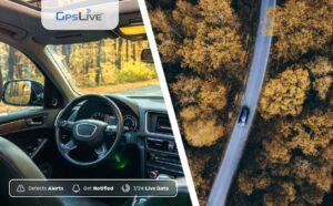
When I see GPS tracking devices on TV, I can see the tracker move across the map continuously, but when I use one myself it jumps from one point to another.
TV and movie producers take some liberties when portraying GPS trackers. It wouldn’t be very interesting to pan a camera over a computer screen to show a dot move every 10 seconds (or even every 30 or 60 seconds). Nobody’s got time for that.
Real-time GPS trackers report their positions at a predetermined interval and are programmed based on the needs of the user. This will be based on a variety of important factors, such as the tracker’s size, what’s being tracked and expected cellular and GPS coverage in the area, among others. Commonly, the fastest reporting interval for most trackers is every 10 seconds.
By not sending a continual stream of data, the tracker can conserve power and potentially operate for weeks, or even months in some cases. One set of constant data would likely last only a few hours at best. It also helps keep costs down. For most applications, reporting every few minutes is more than adequate.
A GPS tracker sends its location at a predetermined interval, which the GPS platform displays as a point on a map, which usually takes a few seconds to process (depending on network traffic). It sends data that way to provide tracking for as long as possible at the best price. Hollywood just can’t show an audience a computer screen that stays static for 30 seconds. For most applications, reporting every few minutes is more than adequate.
Why does the accuracy of my tracker change?
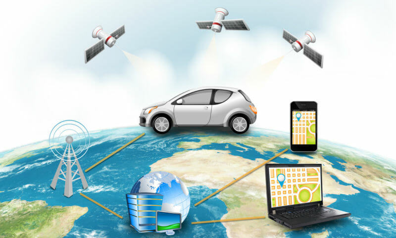
Each of the 27 GPS satellites orbiting the earth is constantly in motion. The system is set up so that at any given time at least four satellites are within the view of any point on the planet. The simple answer is that the more satellites your tracker can pick up signals from, the more accurate the location it provides will be. So, as the number of satellites in view changes, so will your tracker’s accuracy. This is assuming your tracker is in the same with the same conditions. Accuracy will naturally vary when a device is in motion. When walking or driving, tall buildings, mountains, and even trees can obstruct satellite coverage. You may also notice that coverage drops in a certain area that seems to be completely open. This may be due to interference caused by some sort of electronic transmissions, such as those emitted by high power lines.